
Prehistoric Arizona had coastlines from the Paleozoic Seas
Sharks… in Arizona!? Symmorium, an ancestor of sharks, lived in the period of 311 to 290 million years ago, when warm, shallow seas covered much of present-day Arizona.
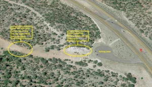
In fact, take a weekend jaunt and visit the Epic Park in Arizona Where You Can Take Home 300-Million-Year-Old Fossils It’s about 60 miles from Prescott. The following is part of an article about the Paleo Site, courtesy of Katie Lawrence.
Over 300 million years ago, Payson, Arizona (60 miles to our East) and the surrounding area was completely underwater. Limestone deposits from that era still remain, and in them are millions of fossilized seashells, coral, and aquatic creatures.
Known as The Paleo Site, this incredible place is frozen in a time before dinosaurs walked the earth. Admission is completely free – and whatever treasures you find are yours to keep!
The Indian Gardens Paleo Site is located 13 miles east of Payson on Highway 260, just before the Kohl’s Ranch turnoff. Very clear signage points straight to the parking area, making it nearly impossible to miss.
No fancy tools are required – a simple hammer and plastic bag work just fine. To find the most fossils, look for a red rock wall about halfway up the hill.
Native Indian history of this area before the white man got here…
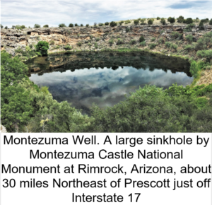
The predominant Indian tribe of the Prescott area… are and were the Yavapai. According to their creation story, the Yavapai believe that their people originated “in the beginning,” or “many years ago,” when either a tree, or a maize plant sprouted from the ground in what is now Montezuma Well, bringing the Yavapai into the world. The word Yavapai means “people of the sun”.
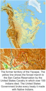
In reality, somewhere between the two Ice Ages of the North American Continent, their Oriental ancestors traversed across the frozen Bering Strait between the Asian Continent and Alaska. They traveled down the western edge of what is now Canada and on down the western coast line of what is now the United States, disbursing into the ice-free lands of America. A rich and unspoiled abundance of hunting and wild edible foods awaited them.
The Yavapai originated from Indian groups that migrated east from the Colorado River region to become the Upland Yumans Indian class. The Yumans were the “parent” of many Arizona area tribes, the Yavapai and Apache being two of the most prominent in Yavapai County. Evidence suggests that they split off to develop as the Yavapai somewhere around 1300 A.D.
Warfare was not uncommon in the Yavapai world, and they made changing alliances for security. Bands formed alliances with other bands, to attack and defend against raids by the Pima and Maricopa Indian bands from the south.
Because of the greater numbers and strength of the Pima and Maricopa tribes, the Yavapai-Apache generally conducted small-scale quick raids, followed by a retreat to avoid counter-attack. The Yavapai defended their lands against Pima incursions, when the Pima would invade to harvest saguaro fruits.
Gosh! Now we just go to our refrigerator or the restaurant to eat. But this was a struggle for families to survive and fighting and killing became part of survival. According to myth, a dispute that began with a mudball fight between children split the Yavapai apart yet again around 1750 A.D.
European contact with the Yavapai Indian tribes
The first recorded contact with the Yavapai was made by one Antonio De Espejo, a Spaniard, who was brought to what is now known as the mountain area of Jerome, Arizona by Hopi guides in 1583, looking for gold. De Espejo was disappointed to find only copper. A few other Spaniards followed in 1598, and again in 1604–1605, looking for gold and the last looking for a route to the sea, which Yavapai had told them about. After this, no other European contact was made for more than 200 years until the 1800s.
 In the intervening time, through contact with other tribes that had more European contact, the Yavapai began to adopt certain European practices. They raised some livestock and planted crops, also adopting some modern tools and weaponry.
In a way, they adopted elements of Christianity. An estimated 25% of the population died as a result of smallpox in the 17th and 18th centuries, smaller losses than for some tribes, but substantial enough to disrupt their societies.
With the use of guns and other weapons, they began to change methods of warfare, diplomacy, and trade. They used livestock raiding, either from other tribes such as the Maricopa, or from Spanish settlements to their south, to supplement their economy. They often acquired human captives in raids, whom they traded as slaves to Spaniards in exchange for European goods.
In the 1820s, beaver trappers, having depleted the beaver population of the Rocky Mountains, began entering Yavapai territory to trap beaver.
After gold was discovered in California in 1849, more White emigrants passed through Yavapai territory than ever had before. Despite the thousands of emigrants passing through their territory, the Yavapai avoided contact with Whites with some exception.
The first fighting between US troops and Yavapai came in early 1837, over a Quechan Yavapai ferry crossing on the Colorado River. The Yavapai used the ferry to transport settlers over the river, into California. After they killed a group led by cutthroat John Glanton, who had taken over the crossing, the US government retaliated by burning the fields of the Yavapai, and taking control of the crossing.
The Oatman family and Olive Oatman Story… a news story sensation in the United States at the time.

In 1851, the Oatman family was ambushed by a group of Yavapai Indians while traveling west by wagon from Yuma. A famine was in progress and it is thought that the 19 Yavapai warriors were angry over the meager supplies that Oatman offered them.
Roy Oatman and his wife were killed, along with four of their seven children. The son, Lorenzo, was left for dead but survived, while sisters Olive and Mary Ann were later sold to Mojaves as slaves.
The story was widely published, and increased white settlers’ fears of attack in Arizona.
Gold
When in early 1863, the Walker Party discovered gold in Lynx Creek (near present-day Prescott, Arizona), it set off a chain of events that would affect white settlements along the Hassayampa and Agua Fria Rivers, the nearby valleys, as well as in Prescott.
Also, our very own Fort Whipple (Now the Prescott Veteran’s Administration Hospital) would be built, all by the end of the year, and all in traditional Yavapai territory.
Interactions with the US government
Before the 1860s, at the time settlers began exploring for gold in the area, the Yavapai occupied an area of approximately 20,000 Square miles bordering the San Francisco Peaks to the north, the Pinaleno Mountains and Mazatzal Mountains to the southeast, and the Colorado River to the west, and almost to the Gila River and the Salt River to the south.
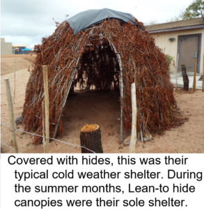
Before being confined to reservations, the Yavapai were mainly hunter-gatherers, following an annual round, migrating to different areas to follow the ripening of different edible plants and movement of game. The main plant foods gathered were walnuts, saguaro fruits, juniper berries, acorns, sunflower seeds, manzanita berries and apples, hackberries, the bulbs of the Quamash, and the greens of the Lamb’s Quarters and other indigenous plants.
From “The Yavapai: Then and Now” by Linda Ogo and Sandra Lynch
On their foraging treks to seasonal gathering places, the Yavapai took time to make ceramic vessels, which were carefully stored for use when needed for collecting and storing plants as they ripened. They gathered great varieties of plants for food, tools, and medicines and also cultivated plants normally associated with village agriculture. By cleverly seeding corn and squash in areas visited in the spring, most young plants survived to provide an additional bounty for the fall hunt. Agave was processed and provided an essential carbohydrate prized for its calcium, sugar, and vitamin C.
Agave was the most crucial harvest, as it was the only plant food available from late fall through early spring. The hearts of the plant were roasted in stone-lined pits, and could be stored for later use.
Primary animals hunted were deer, rabbit, jack rabbit, quail, and woodrat. Fish and water-borne birds were not eaten by most Yavapai groups but over time the Yavapai began eating fish after contact with other branches of the Yavapai tribes who had started eating this protein source.
My posting these Yavapai food sources is greatly influenced by my husband being an author who has published a number of survival and preparedness books. He has put words to the missions, many formerly classified, of members of his Special Forces Chapter. He has given dozens of internet interviews with talk show hosts and has sold thousands of books to date.
The point is… this “desert” is full of wild edible foods. One of the staple foods of the Yavapai was, and still is, the tasty acorn from our very own Pinon Oak Trees. Look in this website for “A little Trivia about our Pinon Oaks Subdivision in Prescott, Arizona” to learn how to water blanch the acorn to make it edible.
The Yavapai Wars
The Yavapai Wars, or the Tonto Wars, were a series of armed conflicts between the Yavapai and Tonto tribes against the United States in Arizona. The period began no later than 1861, with the arrival of American settlers on Yavapai and Tonto land.
At the time, the Yavapai were considered a band of the Western Apache people due to their close relationship with tribes such as the Tonto and Pinal. 366 to 489 Yavapai were killed in massacres and 375 perished in Indian “Removal Deportations” out of 1,400 remaining Yavapai.
Yavapai–Apache Nation
After their defeat by the U.S. Army, the survivors were relocated to the Camp Verde Reservation, near Camp Verde, northeast of Prescott about 40 miles. The Yavapai constructed a five-mile long irrigation ditch that functioned well enough to reap sufficient harvests, making the tribe relatively self-sufficient.
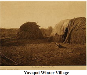
Contractors that worked with the government to supply the reservations were not making the supply sales they expected so they petitioned to have the reservation revoked.
The government shamefully complied and in March 1875, the government closed the reservation. They then marched the residents 180 miles to the San Carlos reservation about 10 miles northeast of Phoenix. More than 100 Yavapai died during this forced winter trek.
By the early 1900s, Yavapai were drifting away from the San Carlos Reservation, and were requesting permission to live on the grounds of the original Camp Verde Reservation. In 1910, 40 acres were set aside as the Camp Verde Indian Reservation, and in the following decade added 248 acres.
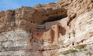
These two reservations were combined in 1937, to form the Camp Verde Yavapai–Apache tribe. Today, the reservation spans 665 acres and tourism contribute greatly to the economy of the tribe, due largely to the presence of many preserved sites, including the Montezuma Castle National Monument.
Yavapai Prescott Indian Reservation
The Yavapai reservation in Prescott was established in 1935, originally consisting of just 75 acres of land formerly occupied by the Fort Whipple Military Reserve. In 1956, an additional 1,320 acres were added. Today, the tribe consists of 159 official members.
The Flavor of our County… Yavapai County
Yavapai County reflects the history of the old west and the future of the new Arizona. Traditional cowboys off the range, modern day gold prospectors with metal detectors and those living a rustic lifestyle in the isolated areas of the County rub shoulders with artists, university and college students, a large retirement population and families raising children in the small towns throughout the County.
Remnants of U.S. Cavalry forts, Indian dwellings, gold rush boomtowns, abandoned mines, Spanish Land Grant ranches, homesteads and vast tracts of uninhabited public lands exist side by side with modern housing developments, industry and business here in the mountain heart of Arizona.

Yavapai County is one of the four original Arizona counties formed in September of 1864, one year after the Arizona Territory was established. The County was also named after the Yavapai Tribe, whose name means the “People of the Sun.”
The County was originally 65,000 square miles and was called the “Mother of Counties” because Apache, Coconino, Gila, Maricopa and Navajo Counties were later formed from it. The territorial government was also born in Yavapai County, the capital being originally located in the County in the City of Prescott.
As with much of the Southwest, the history of the area predates the formation of the Arizona Territory and of the County. Pre-historic Indian artifacts can be found in ancient Indian Pueblos and mounds throughout the County. The greatest concentration of artifacts are found in the Verde Valley where the Upland Yuman Indians arrived around 500 A.D. and created dwellings at Tuzigoot and Montezuma’s Castle.
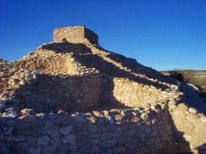
The terrain of the County varies from an elevation of 1,900 feet at its desert low to just under 8,000 feet on its mountain peaks. The diverse terrain includes grasslands, picturesque rock formations, high desert streams and mountain valleys. The major vegetation types in the County are grasslands, pinion-juniper, chaparral, desert grassland and desert scrub.
The climate varies from Sonora Desert in the lower elevations to mid-Canada at the higher elevations. The temperature variations from day-time high to night-time low throughout the year is about 35 degrees.
The County lies in the center of a 100-mile strip of Ponderosa pine forests which crosses the state from the northwest corner to the eastern boundary. The Prescott National Forest, as well as portions of the Coconino and Tonto National Forests, are within the County boundaries.
Only 26 percent of the land in the County is in private hands (individuals or corporations). Thirty-eight percent of the land is administered by the U. S. Forest Service, nine percent by the U.S. Bureau of Land Management, 27 percent by the State of Arizona, and less than 0.5 percent is held in trust as Indian reservations. There are three Indian reservations located in the County – the Yavapai-Prescott Indian Reservation, the Clarkdale and the Camp Verde Indian Reservation.
By 1910, the County had a population of approximately 16,000 people. It rose rapidly to over 24,000 by 1920 and remained somewhat constant for the next 40 years. The 1970 U.S. Census showed a population of nearly 37,000, which reflected the beginning of new, rapid migrations to the County that continued through the end of the 20th Century. During the 2000 U.S. Census, the population was counted at 165,000. The most recent Census in 2010 showed us that Yavapai County experienced another period of growth with a population of 211,033. According to our REALTOR® Association, the 2023 population of the Quad-City Area (Prescott, Prescott Valley, Dewy-Humbolt and Chino Valley) is around 240,000 people and growing.
The first half of the 2000-2010 decade saw a significant increase in both population and development, both regulated and non-regulated. Both increases were primarily due to a housing anomaly whereby easy mortgage terms served to fuel sales and development, resulting in increased housing prices. As the trend reversed in 2006, growth and sales levels flattened, and a significant amount of housing inventory and raw land flooded the market. It is anticipated as these inventories are absorbed that growth will return to the more sustainable pre-2000 levels.
The bulk of the population and the labor force are located in the eight incorporated towns and cities which include Prescott, Prescott Valley, Chino Valley, Jerome, Clarkdale, Sedona, Cottonwood and Camp Verde. The County’s newest municipality is the Town of Dewey-Humboldt, which incorporated in 2004.
Industrial facilities are located in Clarkdale, Cottonwood, Prescott and Prescott Valley.
The County seat is located in the City of Prescott with an annex of County offices in the town of Cottonwood in the Verde Valley. Courtesy of Yavapai County… https://www.yavapaiaz.gov/County-Government/Board-of-Supervisors/County-History
Prescott Arizona and the surrounding area
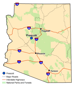
Prescott is 90 miles north of Phoenix in the central highlands of Arizona, amid the largest stand of Ponderosa Pines in the world. Prescott’s mile-high elevation brings four mild seasons, with an average annual daytime temperature of about 70 degrees and more than 300 days of sunshine.
Prescott is the headquarters of the Prescott National Forest and is the Yavapai County seat. The city is named in honor of William Hickling Prescott, a noted historian, and was Arizona’s first Territorial Capital, established in 1864.
Principal Economic Activities
Prescott is the center for trade in the region, with abundant retail establishments, professional services, non-profit service agencies, health care, government, light manufacturing, and distribution centers. Travel, tourism, cultural institutions, performing art centers, sporting events and government offices are important to Prescott’s economy.
Major Medical Facilities
Major medical facilities are Dignity Health Yavapai Regional Medical Center and the Northern Arizona Veterans Administration Hospital which are excellent diagnostic, emergency and treatment centers.
Education Facilities
Education is a vital industry to Prescott. The city houses Embry-Riddle Aeronautical University, Prescott College and Yavapai College, which has a state-of-the-art Career & Technical Education Center. Many class subjects are available for retired people in the area.
Manufacturing
Manufacturing firms such as Sturm Ruger Firearms, CP Technologies, Ester-C, Pure Wafer and Canyon Aero Connect, all call Prescott home.
Scenic Attractions
Prescott is rich in historic and scenic attractions. Sharlot Hall Museum and the Smoki Museum contain pioneer and Native American artifacts. Adding to the cultural experience are more than 800 buildings on the National Register of Historic Buildings. The city boasts numerous events throughout the year including the Whiskey Off-Road and Whiskey Row Marathon starting in late April. The Phippen Western Art Show takes place on Memorial Day weekend.
The Bluegrass Festival and All-Indian Pow Wow occur in June. Prescott Frontier Days Rodeo coincides with the celebration of the Fourth of July. The County Fair and the Faire on the Square kick off in September. As Arizona’s official Christmas City, the Christmas Parade and Courthouse Lighting illuminate the holiday season.
During the summer months, the Courthouse Plaza hosts community events, arts, crafts and car shows. Prescott’s Courthouse Plaza has been honored as one of the Top Ten Public Spaces in the United States by the prestigious American Planning Association. Prescott was also recently named one of the “Coolest Downtowns in North America” by Expedia.
Community Facilities
Prescott offers a wide range of community facilities. The city has five scenic lakes, 16 municipal parks, 15 lighted baseball and softball diamonds and six open-space nature preserves. A network of more than 450 miles of hiking, biking and horseback riding trails wind through the city and into the adjacent Prescott National Forest.
In recent years, these amenities earned Prescott the title of “Top Outdoor Adventure Town.” Additionally, Prescott has libraries, museums, performing arts theaters, art galleries, public and private 18-hole golf courses, racquet ball.
Basic Information on Prescott
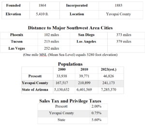
Courtesy of the Arizona Commerce Authority
That’s it for this section of Fiona Oakley’s Pinon Oaks Folks website… I hope you enjoyed it!!